Amphipolis: The mapping of the Kasta hill
The Ministry of Culture has issued this afternoon, a new communication on excavations in Kasta hill Amphipolis, by doing a "systematic review" on the works done and publishing a new picture which shows the geophysical 'incisions'.
In a statement the Ministry of Culture notes: "the geophysical and geological mapping of Kasta hill Amphipolis, began November 11, 2014 and conducted slowly, due to unfavorable weather conditions.
The research team consists of the Head-teacher Gregoris Tsokas, the Director of the Laboratory of Applied Geophysics of AUTH, Professor Panagiotis Tsourlos, the Assoc. Professor George Vargemezis, graduate students and other scientific staff of the Laboratory. Also, participate: the professor of sedimentology, George Syridis, the paleo-seismologist professor Spiros Pavlidis, and the geologist of the ministry, Dr. Evangelos Kambouroglou".
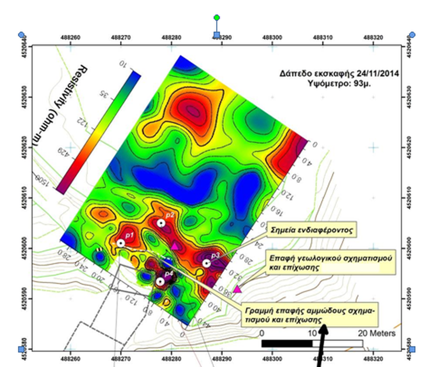
Referring to the photo that was published, the Ministry of Culture states that this shows that the ancient trench stops in a short distance north of the dome, the northernmost part of which is indicated by the plastic cover.
In the same communication, it is analyzed the scientific way of the process: "The research focused on the creation of a model of the area of that season, before the intervention for the construction of the dome. For this purpose, we made geological and tectonic observations and many electrical tomographies.
The recent removal of the soil and the earlier excavations have provided concrete and conclusive evidence of the position and characteristics of the geological formations. In this phase was investigated the subsoil in the area around the dome, ie the gradient north and the berm which was formed from the previous excavation, east and west. The prospecting of areas was held by applying the method of electrical resistivity tomography and in very small extent the method of subsurface radar (known as GPR - Ground Penetrating Radar) due to methodological limitations, in the specific geological and archaeological conditions.
The investigation confirmed that the hill has a mixed structure, with most of it to be natural and the backfill by human hand covers a relatively small part. The dome was constructed and erected within the trench, which was opened in the geological formations of the slopes of the existing hill, which ends a few meters north of the dome.
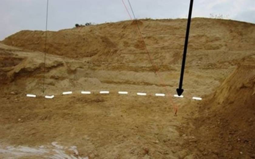
The geophysical search gave illustrations of the interior of the hill, where static structures were identified and were further investigated. In one case north of the dome, the removal of soil revealed that the subsurface structure, illustrated with electrical scans, was sand, ie natural formation. In the horizontal resonance imaging, the warm colors indicate areas with high specific electrical resistance and respectively the cool colors indicate the areas with low.
The communication concludes that there are points that need further study and that the investigation will continue, "The scans, which have given this image, were held in the soil surface before removing the soil, which was higher than the level of 93m. The points, which should be further investigated, marked as "landmarks". The white line in the horizontal resonance imaging is marked on the ground also. (Photo 1) It is evident that the anomaly of the tomography is due to sandy geological formation. Note that the anomalies with high resistance values, which are shown in the northern part of the horizontal section, are not evaluated because they are within the natural formations.